My Predicted 2020 Presidential Electoral Map

I’m predicting that Joe Biden will win a slim electoral majority, as well as a large popular-vote advantage, over Donald Trump.

election 2020

In this particular scenario, the swing states all go for Trump, except for Arizona and Florida, which Biden wins. Both Arizona and Florida have large elderly populations, and I don’t think they’re much caring for the way Trump is treating them as disposable people when it comes to the COVID-19 pandemic.

If you would like to make your own prediction-map, the website to visit to do so is www.270towin.com.

Silly U.S. Map Puzzle #5

What do the colors on this map mean?

mappuzzle5

If you wish to check your answer, or just what to know what the solution is, just scroll down.

.

.

.

.

.

.

.

And keep on scrollin’. . . .

.

.

.

.

Solution:

Of the other 49 states in the USA, how many are adjacent to this one? The answer to this question determines the color of each state.

One point of clarification: if it takes a lengthy trip by boat or ship to get there, I didn’t count it as an adjacent state . . . so, for example, Minnesota and Michigan didn’t make each other’s lists. Simply going over a bridge isn’t enough for this sort of separation, though, which is why Arkansas and Tennessee did make each others’ lists of adjacent states. Had I interpreted water borders differently, this map would have some differences.

Another way this map could be altered would be to count states that meet others only at a single point, rather than a border with non-zero length. This would change the colors of the “four corners” states of Arizona, Utah, New Mexico, and Colorado, but would have no effect on the other 46 states.

Silly U.S. Map Puzzles #4a and 4b

First, for puzzle #4a, what are the meanings of the colors on this map?

mapquiz4a-letters

For puzzle #4b, what do the colors mean on this second, similar map?

mapquiz4b-characters

To find the answers, simply scroll down.

.

.

.

.

.

.

Keep scrolling….

.

.

.

.

.

Solution:

In the first map, consider the number of letters in the name of each state. Is this number prime or composite?

In the second map, consider the number of characters, rather than letters, in each state’s name. This number is different for states with two-word names, due to the single character, a blank space, needed to separate the two words. Again: prime, or composite?

Silly U.S. Map Puzzle #3

What is represented by the colors on this map?

mapquiz3

The answer may be found by scrolling down.

.

.

.

.

.

.

.

Keep scrolling….

.

.

.

.

Answer:

Do any of the borders of this state contain squiggles? (Note: if you think New Mexico is the wrong color, check the part of that state which borders El Paso, Texas.)

Silly U.S. Map Puzzle #2

What is represented by the colors on this map?

mapquiz2

If you give up, you can scroll down to find the answer.

.

.

.

.

.

.

Keep scrolling….

.

.

.

Answer: the colors show whether the name of each state starts with a letter in the first, or second, half of the alphabet.

Silly U.S. Map Puzzle #1

What is represented by the colors on this map?

mapquiz1

If you decide to give up, you can scroll down for the answer . . . but, I promise, the solution to this puzzle is extremely simple.

.

.

.

.

.

.

.

.

.

.

.

.

.

.

.

.

.

.

Keep scrolling, if you’re looking for the answer….

.

.

.

.

.

Answer:

The map shows how many words are in the name of each state.

Places I Have Been, #2: When Was I Last There?

This is a more detailed version of one of the earliest posts on this blog, “Places I Have Been.” In this version, I color-coded the states and provinces to show when I was last in each of these places (the color-coding is explained below the picture). Also, no, I haven’t left North America — yet — but visits to all the other continents on Earth, plus the Moon, are definitely on my lifetime “to do” list.

placesihavebeen-1

Here’s the color-key. It starts in the present, and then proceeds in reverse chronological order.

Red — I’m here right now. Arkansas is also the state where I have spent well over 90% of my life, and I was born here, as well, 47½ years ago (January, 1968).

Pink — These are states I’ve been to since turning 45, not counting where I am at the moment. It’s also the set of states my wife and I have visited together — so far.

Purple — I was last in each of these states during the first half of my forties.

Dark blue — I was last in Kansas in my thirties, flying there, with two other math teachers, for an educational conference.

Yellow — Louisiana is the only state which I last visited in my twenties.

Green — These are states I last visited at age nineteen. So far, that’s the furthest I have traveled in a single year. The green Mexican state on the map is Chihuahua, where I visited Cuidad Juárez, just across the Rio Grande from El Paso, Texas.

Light blue — These are the states and provinces I last visited as a “tween” (ages 10-12). The Northern vacation trip was with my family, and, so far, that’s the only time I’ve been to Canada. Virginia made the map when I won a trip to Washington, DC (too small to be seen above), as one of a busload of young newspaper carriers, for selling twenty newspaper subscriptions to Arkansas Gazette — one of America’s many “lost newspapers,” and one which I very much miss. Alabama and Florida are included because of a field trip, all the way to Key West, with a college class — one of the benefits of growing up as a “professor’s kid” who spent a lot of time on campus.

Brown — I have been to South Carolina once, but I wasn’t even close to ten years old at the time, and now I barely remember this family trip to the Atlantic coast.

Gray — I was so young, when my parents took me to Colorado, that I have no memories from that trip at all. I don’t think my younger sister had even been born yet, in fact. All I remember is being told, much later, that, yes, I have been to Colorado.

My Australia Story

australia

I once got into a huge argument, as a 7th grade student, in a “talented and gifted” section of Social Studies. The issue:  how many countries are there in the continent of Australia?

The assignment was to choose a continent, and draw a map of it on a full-size posterboard. I had worked for hours on this map, only to get it back, ruined, for the teacher had taken a red ball-point pen, slashed through my line “state and territorial boundaries” in my map’s key, and had written, as a correction, “not states — COUNTRIES.” She also docked points from my grade, but that was a minor issue, to me, compared to her ruining my map. She could have, at least, written her incorrect comment on the back of my map!

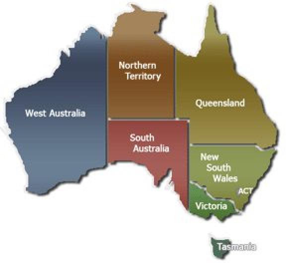
When I confronted her about her mistake, she maintained that the political divisions you see above are independent countries. In my opinion, “Northern Territory,” especially, doesn’t sound particularly sovereign, and I said so, but she may not have understood the definition of “sovereign,” for that did not work. Confronted with this absurd situation, I proceeded to grab the “Q” volume of a nearby encyclopedia, and began reading the article about Queensland, loudly enough for the entire class to hear: “Queensland:  one of the states of Australia….” I freely admit that, at the time, my goal was to embarrass and humiliate her right out of the teaching profession — for the benefit of her present and future students. I’ve changed my approach, a lot, since then.

A huge brouhaha ensued, and we ended up taking each other to the assistant principal’s office:  her, to report a disruptive and defiant student; and me, to report an incompetent teacher, who, in my view, at that age, should have been fired on the spot. Dealing with this situation was probably one of the stranger, and more difficult, situations of that assistant principal’s career, for he knew that Australia is both a single country, and a continent — but he could not, for political reasons I did not yet understand, agree with me in front of this teacher. As for me, I was simply incredulous that someone could be a certified social studies teacher, and not know this basic fact about world geography. The whole scenario, to me, was surreal.

The assistant principal handled it well. To the teacher, he said, “You can go back to class — I’ll handle Robert.” He then “handled” me, after she left, in the only way that could have possibly worked:  with an apology, and a polite request to do my best to endure her ignorance until the upcoming end of the year. I respect honesty, was being given a request, not an order, and he had conceded that I was correct. I therefore chose to cooperate — with his polite request.

If he had not taken this approach, I likely would have added him to the list I had, at the time, of people (a mixture of administrators and teachers) whom I was trying to drive out of the education profession, for the benefit of all — but he did the right thing, thus earning my respect.

As for the teacher, I survived the rest of her class, brain intact, and assume she is now retired, this being well over thirty years ago. I’m now in my twentieth year as a teacher, myself, and am pleased to report that average teacher quality has dramatically improved since this fiasco happened. (I wish I could say the same about average administrator quality, but there are, at least, a few competent people working in that field, as well.) During my years of teaching, I haven’t encountered a single teacher who lacked this basic bit of knowledge about world geography. In fact, I count, among my colleagues, many of the smartest people I know.

I am glad, however, that I don’t have to call the teacher in this story a colleague. I simply cannot respect willful, stubborn ignorance, especially in the face of evidence that one is wrong. When one of my students catches me making a mistake, I do the right thing: I thank them, make certain everyone understands the correction, and then we move on with the lesson. That’s what this 7th grade teacher of mine should have done, as well.

North American Geographical Oddity

You’re standing on the mainland of North America — not on an island. From where you are, you can travel due East, and you’ll come to the Pacific Ocean. If you travel due West, however, you will come to the Atlantic Ocean. What’s more, this is true for a relatively large percentage of locations in the country where you are located — a greater percentage than would be the case for any other country on the North American continent, if there even are others.

In what country are you standing?

(Scroll down for the answer.)

.

.

.

.

.

.

.

.

.

.

.

panama

You’re in Panama! Now, before anyone protests that Panama is in Central America, not North America, let me point out that Central America is part of the North American continent, just as Europe and India are part of the Eurasian continent. (Yes, I looked them up.)